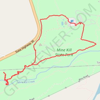
Mine Kill Falls via Orange Trail
- Distance: 2.7 mi
- Elevation gain: 161 m
- Maximum elevation: 375 m
- Elevation loss: 161 m
- Minimum elevation: 282 m
- Moving time: 1 h 6 m
- Moving speed: 2.4 mph
- Maximum speed: 4.3 mph
- Total time: 1 h 15 m
- Global speed: 2.1 mph
Interactive trail map
Trail profile
- Distance: 2.7 mi
- Elevation gain: 161 m
- Maximum elevation: 375 m
- Elevation loss: 161 m
- Minimum elevation: 282 m
- Moving time: 1 h 6 m
- Moving speed: 2.4 mph
- Maximum speed: 4.3 mph
- Total time: 1 h 15 m
- Global speed: 2.1 mph
About this trail
Name: Mine Kill Falls via Orange Trail trail, distance, elevation, map, profile, GPS track
Coordinates: 42.42983 -74.46939 42.43821 -74.45438
Other hiking, mountain biking, running and outdoor activity trails
Click on a trail to view its statistics, map and profile.
Long Path
United States > New York > Schoharie County
Distance: 13.2 mi • Elevation gain: 625 m • Maximum elevation: 386 m