Table Rock Trail from Pinnacle Lake in Table Rock State Park
The Table Rock Trail offers a visually rewarding experience with panoramic views of the surrounding mountains and the Table Rock Reservoir. As you ascend, you'll pass through lush, preserved forest landscapes and cross over multiple creeks, where small waterfalls add to the scenic charm of the hike. At the summit, the 360-degree views encompass the iconic Table Rock monolith and far-reaching vistas of the Blue Ridge Mountains, making the effort worthwhile for those seeking both a physical challenge and breathtaking natural beauty. #Hiking #Mountain #Forest #Nature #Lake #Waterfall
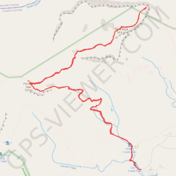
- Distance: 7.0 mi
- Elevation gain: 722 m
- Maximum elevation: 944 m
- Elevation loss: 724 m
- Minimum elevation: 357 m
- Moving time: 3 h 12 m
- Moving speed: 2.2 mph
- Maximum speed: 5.5 mph
- Total time: 3 h 26 m
- Global speed: 2.0 mph
Interactive trail map
Trail profile
- Distance: 7.0 mi
- Elevation gain: 722 m
- Maximum elevation: 944 m
- Elevation loss: 724 m
- Minimum elevation: 357 m
- Moving time: 3 h 12 m
- Moving speed: 2.2 mph
- Maximum speed: 5.5 mph
- Total time: 3 h 26 m
- Global speed: 2.0 mph
About this trail
Name: Table Rock Trail from Pinnacle Lake in Table Rock State Park trail, distance, elevation, map, profile, GPS track
Start: Pinnacle Mountain Trail, Pickens County, South Carolina, United States (35.03217 -82.70074)
End: Pinnacle Mountain Trail, Pickens County, South Carolina, United States (35.03214 -82.70032)
Coordinates: 35.03213 -82.71797 35.05321 -82.69945
Other hiking, mountain biking, running and outdoor activity trails
Click on a trail to view its statistics, map and profile.
Carrick Creek Loop Trail in Table Rock State Park
United States > South Carolina > Pickens County
The Carrick Creek Loop Trail is a delightful hike that immerses visitors in the beauty of South Carolina's upcountry. Along the route, you can enjoy the serene sounds of bubbling streams and discover several charming waterfalls nestled within a lush forest setting, creating a peaceful escape from urban life.…
Distance: 1.9 mi • Elevation gain: 122 m • Maximum elevation: 473 m