Thank you for supporting this site ❤️
Make a donation
Make a donation
Gear up for your next adventure:
As an Amazon Associate, this site earns from qualifying purchases at no extra cost to you.
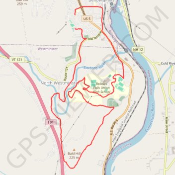
Lots of waterfalls!
- Distance: 7.1 mi
- Elevation gain: 219 m
- Maximum elevation: 160 m
- Elevation loss: 228 m
- Minimum elevation: 83 m
- Moving time: 59 m 45 s
- Moving speed: 7.1 mph
- Maximum speed: 12.1 mph
- Total time: 1 h 10 m
- Global speed: 6.0 mph
Interactive trail map
Thank you for supporting this site ❤️
Make a donation
Make a donation
Gear up for your next adventure:
As an Amazon Associate, this site earns from qualifying purchases at no extra cost to you.
Trail profile
- Distance: 7.1 mi
- Elevation gain: 219 m
- Maximum elevation: 160 m
- Elevation loss: 228 m
- Minimum elevation: 83 m
- Moving time: 59 m 45 s
- Moving speed: 7.1 mph
- Maximum speed: 12.1 mph
- Total time: 1 h 10 m
- Global speed: 6.0 mph
Thank you for supporting this site ❤️
Make a donation
Make a donation
Gear up for your next adventure:
As an Amazon Associate, this site earns from qualifying purchases at no extra cost to you.
About this trail
Name: Lots of waterfalls! trail, distance, elevation, map, profile, GPS track
Coordinates: 43.10270 -72.45735 43.13281 -72.43883
Thank you for supporting this site ❤️
Make a donation
Make a donation
Gear up for your next adventure:
As an Amazon Associate, this site earns from qualifying purchases at no extra cost to you.
Other hiking, mountain biking, running and outdoor activity trails
Click on a trail to view its statistics, map and profile.