Thank you for supporting this site ❤️
Make a donation
Make a donation
Gear up for your next adventure:
As an Amazon Associate, this site earns from qualifying purchases at no extra cost to you.
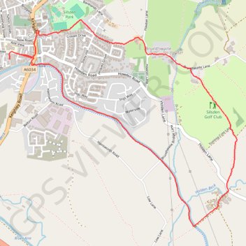
Trails and canal from Silsden
- Distance: 3.1 mi
- Elevation gain: 68 m
- Maximum elevation: 157 m
- Elevation loss: 67 m
- Minimum elevation: 104 m
- Moving time: 53 m 39 s
- Moving speed: 3.5 mph
- Maximum speed: 9.7 mph
- Total time: 53 m 39 s
- Global speed: 3.5 mph
Interactive trail map
Thank you for supporting this site ❤️
Make a donation
Make a donation
Gear up for your next adventure:
As an Amazon Associate, this site earns from qualifying purchases at no extra cost to you.
Trail profile
- Distance: 3.1 mi
- Elevation gain: 68 m
- Maximum elevation: 157 m
- Elevation loss: 67 m
- Minimum elevation: 104 m
- Moving time: 53 m 39 s
- Moving speed: 3.5 mph
- Maximum speed: 9.7 mph
- Total time: 53 m 39 s
- Global speed: 3.5 mph
Thank you for supporting this site ❤️
Make a donation
Make a donation
Gear up for your next adventure:
As an Amazon Associate, this site earns from qualifying purchases at no extra cost to you.
About this trail
Name: Trails and canal from Silsden trail, distance, elevation, map, profile, GPS track
Coordinates: 53.90129 -1.94040 53.91421 -1.91626
Topography: Bradford topographic map, elevation, terrain
Thank you for supporting this site ❤️
Make a donation
Make a donation
Gear up for your next adventure:
As an Amazon Associate, this site earns from qualifying purchases at no extra cost to you.
Other hiking, mountain biking, running and outdoor activity trails
Click on a trail to view its statistics, map and profile.
Otley - Draughton/Skipton Moor and return
United Kingdom > England > Leeds
Distance: 25.7 mi • Elevation gain: 456 m • Maximum elevation: 318 m