Mount Rose hiking loop trail
Cook County Hiking
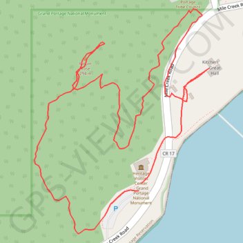
- Distance: 1.3 mi
- Elevation gain: 90 m
- Maximum elevation: 264 m
- Elevation loss: 91 m
- Minimum elevation: 187 m
- Moving time: 34 m 25 s
- Moving speed: 2.2 mph
- Maximum speed: 4.5 mph
- Total time: 40 m 34 s
- Global speed: 1.9 mph
Interactive trail map
Trail profile
- Distance: 1.3 mi
- Elevation gain: 90 m
- Maximum elevation: 264 m
- Elevation loss: 91 m
- Minimum elevation: 187 m
- Moving time: 34 m 25 s
- Moving speed: 2.2 mph
- Maximum speed: 4.5 mph
- Total time: 40 m 34 s
- Global speed: 1.9 mph
About this trail
Name: Mount Rose hiking loop trail trail, distance, elevation, map, profile, GPS track
Start: Mile Creek Road, Grand Portage, Cook County, Minnesota, 55605, United States (47.96042 -89.68666)
End: Mile Creek Road, Grand Portage, Cook County, Minnesota, 55605, United States (47.96029 -89.68671)
Coordinates: 47.95954 -89.68945 47.96348 -89.68488