Import a GPX file

Taylors Beach walking tracks

  • Distance: 1.7 mi
  • Elevation gain: 34 m
  • Maximum elevation: 16 m
  • Elevation loss: 32 m
  • Minimum elevation: 0 m
  • Moving time: 48 m 12 s
  • Moving speed: 2.1 mph
  • Maximum speed: 4.4 mph
  • Total time: 57 m 9 s
  • Global speed: 1.8 mph

Interactive trail map

Trail profile

  • Distance: 1.7 mi
  • Elevation gain: 34 m
  • Maximum elevation: 16 m
  • Elevation loss: 32 m
  • Minimum elevation: 0 m
  • Moving time: 48 m 12 s
  • Moving speed: 2.1 mph
  • Maximum speed: 4.4 mph
  • Total time: 57 m 9 s
  • Global speed: 1.8 mph

About this trail

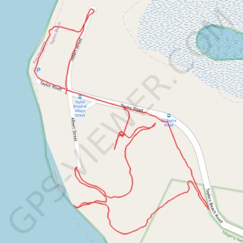
Name: Taylors Beach walking tracks trail, distance, elevation, map, profile, GPS track

Start: Taylor Road, Taylors Beach, Port Stephens Council, New South Wales, 2316, Australia (-32.73706 152.05629)

End: Taylor Road, Taylors Beach, Port Stephens Council, New South Wales, 2316, Australia (-32.73741 152.05794)

Coordinates: -32.74043 152.05539 -32.73502 152.06037

Gear up for your next adventure:

🧼Technical Clothing Wash - Special soap to clean and restore waterproof membranes
🥫Expedition Meals - Lightweight, high-calorie nutrition for long-distance hikers
🧺Microfibre Travel Towels - Fast-drying and compact towels for wild swimming and camping
🧭Emergency Beacons - Safety beacons for remote outdoor locations
🛌Sleeping Mats - Insulated mats for comfortable outdoor sleeping

As an Amazon Associate, this site earns from qualifying purchases at no extra cost to you.