Thank you for supporting this site ❤️
Make a donation
Make a donation
Gear up for your next adventure:
As an Amazon Associate, this site earns from qualifying purchases at no extra cost to you.
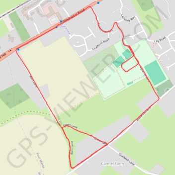
Four Marks - a run!
- Distance: 2.0 mi
- Elevation gain: 18 m
- Maximum elevation: 186 m
- Elevation loss: 18 m
- Minimum elevation: 172 m
- Moving time: 17 m 21 s
- Moving speed: 7.0 mph
- Maximum speed: 8.7 mph
- Total time: 17 m 21 s
- Global speed: 7.0 mph
Interactive trail map
Thank you for supporting this site ❤️
Make a donation
Make a donation
Gear up for your next adventure:
As an Amazon Associate, this site earns from qualifying purchases at no extra cost to you.
Trail profile
- Distance: 2.0 mi
- Elevation gain: 18 m
- Maximum elevation: 186 m
- Elevation loss: 18 m
- Minimum elevation: 172 m
- Moving time: 17 m 21 s
- Moving speed: 7.0 mph
- Maximum speed: 8.7 mph
- Total time: 17 m 21 s
- Global speed: 7.0 mph
Thank you for supporting this site ❤️
Make a donation
Make a donation
Gear up for your next adventure:
As an Amazon Associate, this site earns from qualifying purchases at no extra cost to you.
About this trail
Name: Four Marks - a run! trail, distance, elevation, map, profile, GPS track
End: Four Marks, East Hampshire, Hampshire, England, GU34 5FD, United Kingdom (51.10525 -1.05581)
Coordinates: 51.10003 -1.06350 51.10696 -1.05373
Topography: East Hampshire topographic map, elevation, terrain
Thank you for supporting this site ❤️
Make a donation
Make a donation
Gear up for your next adventure:
As an Amazon Associate, this site earns from qualifying purchases at no extra cost to you.