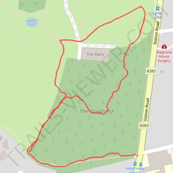
Sunningdale Park Woodland Path
- Distance: 0.8 mi
- Elevation gain: 14 m
- Maximum elevation: 66 m
- Elevation loss: 11 m
- Minimum elevation: 57 m
- Moving time: 14 m 2 s
- Moving speed: 3.3 mph
- Maximum speed: 5.6 mph
- Total time: 14 m 2 s
- Global speed: 3.3 mph
Interactive trail map
Trail profile
- Distance: 0.8 mi
- Elevation gain: 14 m
- Maximum elevation: 66 m
- Elevation loss: 11 m
- Minimum elevation: 57 m
- Moving time: 14 m 2 s
- Moving speed: 3.3 mph
- Maximum speed: 5.6 mph
- Total time: 14 m 2 s
- Global speed: 3.3 mph
About this trail
Name: Sunningdale Park Woodland Path trail, distance, elevation, map, profile, GPS track
Coordinates: 51.39768 -0.63827 51.40070 -0.63471
Topography: Royal Borough of Windsor and Maidenhead topographic map, elevation, terrain