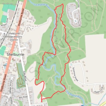
Laplatte Nature Park Loop Trail
- Distance: 2.4 mi
- Elevation gain: 99 m
- Maximum elevation: 77 m
- Elevation loss: 99 m
- Minimum elevation: 30 m
- Moving time: 48 m 48 s
- Moving speed: 2.9 mph
- Maximum speed: 5.9 mph
- Total time: 48 m 48 s
- Global speed: 2.9 mph
Interactive trail map
Trail profile
- Distance: 2.4 mi
- Elevation gain: 99 m
- Maximum elevation: 77 m
- Elevation loss: 99 m
- Minimum elevation: 30 m
- Moving time: 48 m 48 s
- Moving speed: 2.9 mph
- Maximum speed: 5.9 mph
- Total time: 48 m 48 s
- Global speed: 2.9 mph
About this trail
Name: Laplatte Nature Park Loop Trail trail, distance, elevation, map, profile, GPS track
Coordinates: 44.37228 -73.22409 44.38473 -73.21774
Other hiking, mountain biking, running and outdoor activity trails
Click on a trail to view its statistics, map and profile.
Around lake Champlain with ferry between Essex NY/Charlotte VT
United States > Vermont > Chittenden County > South Burlington
Distance: 138.4 mi • Elevation gain: 1,742 m • Maximum elevation: 198 m