Ludington State Park
Hike through Ludington State Park along Big Sable River between Hamlin Lake and Lake Michigan via Hamlin Dam. #Hiking #Nature #Park #Forest #River #Lake #Dam
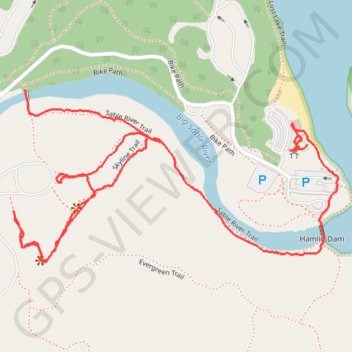
- Distance: 1.8 mi
- Elevation gain: 35 m
- Maximum elevation: 195 m
- Elevation loss: 33 m
- Minimum elevation: 180 m
- Moving time: 1 h 1 m
- Moving speed: 1.7 mph
- Maximum speed: 7.8 mph
- Total time: 1 h 15 m
- Global speed: 1.4 mph
Interactive trail map
Trail profile
- Distance: 1.8 mi
- Elevation gain: 35 m
- Maximum elevation: 195 m
- Elevation loss: 33 m
- Minimum elevation: 180 m
- Moving time: 1 h 1 m
- Moving speed: 1.7 mph
- Maximum speed: 7.8 mph
- Total time: 1 h 15 m
- Global speed: 1.4 mph
About this trail
Name: Ludington State Park trail, distance, elevation, map, profile, GPS track
End: Bike Path, Hamlin Township, Mason County, Michigan, United States (44.03440 -86.49265)
Coordinates: 44.03202 -86.50095 44.03551 -86.49179
Other hiking, mountain biking, running and outdoor activity trails
Click on a trail to view its statistics, map and profile.
Hike to Inspiration Point
United States > Michigan > Mason County
Distance: 1.7 mi • Elevation gain: 51 m • Maximum elevation: 209 m