Import a GPX file

Simon's Town

#Bike #Loop

  • Distance: 18.9 mi
  • Elevation gain: 581 m
  • Maximum elevation: 261 m
  • Elevation loss: 584 m
  • Minimum elevation: 3 m

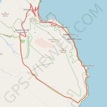
Interactive trail map

Trail profile

  • Distance: 18.9 mi
  • Elevation gain: 581 m
  • Maximum elevation: 261 m
  • Elevation loss: 584 m
  • Minimum elevation: 3 m

About this trail

Other hiking, mountain biking, running and outdoor activity trails

Click on a trail to view its statistics, map and profile.

Simon's Town - Cape Town

South Africa > Western Cape > City of Cape Town > Simon's Town

#Bike

Distance: 33.5 mi • Elevation gain: 1,127 m • Maximum elevation: 184 m

Gear up for your next adventure:

🗺️Ordnance Survey Maps - Essential paper maps for hiking across the UK national parks
🧭Professional Hiking Compasses - High-precision liquid-filled compasses for map reading and orientation
🧤Thermal Touchscreen Gloves - Stay warm while operating your GPS or smartphone camera
Insulated Travel Mugs - Keep drinks hot while surveying the landscape from a summit
🔦Outdoor Torches - Reliable torches for night navigation

As an Amazon Associate, this site earns from qualifying purchases at no extra cost to you.