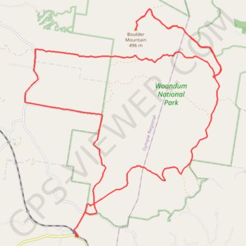
Traveston - Mount Boulder
Interactive trail map
Trail profile
- Distance: 24.9 mi
- Elevation gain: 877 m
- Maximum elevation: 487 m
- Elevation loss: 877 m
- Minimum elevation: 68 m
About this trail
Name: Traveston - Mount Boulder trail, distance, elevation, map, profile, GPS track
Start: Traveston Cooran Road, Traveston, Gympie Regional, Queensland, Australia (-26.32124 152.78359)
End: Traveston Cooran Road, Traveston, Gympie Regional, Queensland, Australia (-26.32126 152.78356)
Coordinates: -26.32129 152.76485 -26.24607 152.83713
Other hiking, mountain biking, running and outdoor activity trails
Click on a trail to view its statistics, map and profile.
Kandanga Wrattens Widgee Loop
Australia > Queensland > Tewantin
Distance: 136.9 mi • Elevation gain: 3,584 m • Maximum elevation: 684 m
Noosa Enduro MTB Course
Australia > Queensland > Tewantin
Distance: 56.9 mi • Elevation gain: 1,691 m • Maximum elevation: 460 m