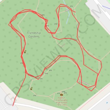
Friendship Gardens
- Distance: 0.5 mi
- Elevation gain: 14 m
- Maximum elevation: 75 m
- Elevation loss: 21 m
- Minimum elevation: 64 m
- Moving time: 10 m 5 s
- Moving speed: 3.1 mph
- Maximum speed: 4.8 mph
- Total time: 10 m 5 s
- Global speed: 3.1 mph
Interactive trail map
Trail profile
- Distance: 0.5 mi
- Elevation gain: 14 m
- Maximum elevation: 75 m
- Elevation loss: 21 m
- Minimum elevation: 64 m
- Moving time: 10 m 5 s
- Moving speed: 3.1 mph
- Maximum speed: 4.8 mph
- Total time: 10 m 5 s
- Global speed: 3.1 mph
About this trail
Name: Friendship Gardens trail, distance, elevation, map, profile, GPS track
Coordinates: 49.20714 -122.91081 49.20803 -122.90956
Other hiking, mountain biking, running and outdoor activity trails
Click on a trail to view its statistics, map and profile.