Vucjanka-The best canyon trail
- Distance: 4.2 mi
- Elevation gain: 383 m
- Maximum elevation: 519 m
- Elevation loss: 380 m
- Minimum elevation: 315 m
- Moving time: 1 h 44 m
- Moving speed: 2.4 mph
- Maximum speed: 12.0 mph
- Total time: 3 h 7 m
- Global speed: 1.4 mph
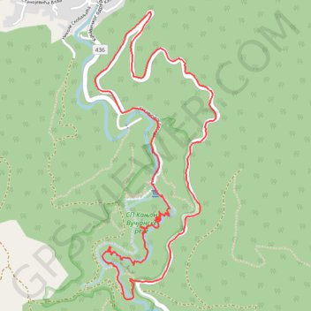
Interactive trail map
Trail profile
- Distance: 4.2 mi
- Elevation gain: 383 m
- Maximum elevation: 519 m
- Elevation loss: 380 m
- Minimum elevation: 315 m
- Moving time: 1 h 44 m
- Moving speed: 2.4 mph
- Maximum speed: 12.0 mph
- Total time: 3 h 7 m
- Global speed: 1.4 mph
About this trail
Name: Vucjanka-The best canyon trail trail, distance, elevation, map, profile, GPS track
Coordinates: 42.84613 21.91168 42.86206 21.92080
Other hiking, mountain biking, running and outdoor activity trails
Click on a trail to view its statistics, map and profile.
2022_Yu
Slovenia > Ajdovščina > Žapuže
Distance: 1,526.9 mi • Elevation gain: 32,048 m • Maximum elevation: 1,950 m
Vučje-Skobaljić grad-Sokolica-vrh Kita 1020mnv
Serbia > Central Serbia > Jablanica Administrative District > Vucje
Distance: 11.6 mi • Elevation gain: 1,039 m • Maximum elevation: 1,014 m