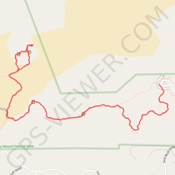
Rosy Mound Natural Area
Foot
- Distance: 1.4 mi
- Elevation gain: 32 m
- Maximum elevation: 212 m
- Elevation loss: 28 m
- Minimum elevation: 181 m
- Moving time: 40 m 33 s
- Moving speed: 2.1 mph
- Maximum speed: 6.1 mph
- Total time: 54 m 58 s
- Global speed: 1.5 mph
Interactive trail map
Trail profile
- Distance: 1.4 mi
- Elevation gain: 32 m
- Maximum elevation: 212 m
- Elevation loss: 28 m
- Minimum elevation: 181 m
- Moving time: 40 m 33 s
- Moving speed: 2.1 mph
- Maximum speed: 6.1 mph
- Total time: 54 m 58 s
- Global speed: 1.5 mph
About this trail
Name: Rosy Mound Natural Area trail, distance, elevation, map, profile, GPS track
Coordinates: 43.01859 -86.23225 43.02275 -86.22152