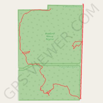
Bradford Nature Reserve
- Distance: 3.6 mi
- Elevation gain: 39 m
- Maximum elevation: 365 m
- Elevation loss: 63 m
- Minimum elevation: 333 m
- Moving time: 49 m 7 s
- Moving speed: 4.4 mph
- Maximum speed: 14.9 mph
- Total time: 1 h 19 m
- Global speed: 2.7 mph
Interactive trail map
Trail profile
- Distance: 3.6 mi
- Elevation gain: 39 m
- Maximum elevation: 365 m
- Elevation loss: 63 m
- Minimum elevation: 333 m
- Moving time: 49 m 7 s
- Moving speed: 4.4 mph
- Maximum speed: 14.9 mph
- Total time: 1 h 19 m
- Global speed: 2.7 mph
About this trail
Name: Bradford Nature Reserve trail, distance, elevation, map, profile, GPS track
Start: Bradford Road, Minigin, Shire Of Narrogin, Western Australia, Australia (-32.89879 117.03821)
End: Bradford Road, Minigin, Shire Of Narrogin, Western Australia, Australia (-32.90920 117.04229)
Coordinates: -32.90923 117.03386 -32.89827 117.04266