Hike of the Pulaski Tunnel Trail
Evening hike
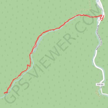
- Distance: 4.1 mi
- Elevation gain: 297 m
- Maximum elevation: 1,130 m
- Elevation loss: 295 m
- Minimum elevation: 886 m
- Moving time: 1 h 27 m
- Moving speed: 2.8 mph
- Maximum speed: 10.6 mph
- Total time: 1 h 52 m
- Global speed: 2.2 mph
Interactive trail map
Trail profile
- Distance: 4.1 mi
- Elevation gain: 297 m
- Maximum elevation: 1,130 m
- Elevation loss: 295 m
- Minimum elevation: 886 m
- Moving time: 1 h 27 m
- Moving speed: 2.8 mph
- Maximum speed: 10.6 mph
- Total time: 1 h 52 m
- Global speed: 2.2 mph
About this trail
Name: Hike of the Pulaski Tunnel Trail trail, distance, elevation, map, profile, GPS track
Start: Pulaski Tunnel Trail, Shoshone County, Idaho, 83873, United States (47.45929 -115.93509)
End: Moon Pass Road, Shoshone County, Idaho, 83873, United States (47.45931 -115.93502)
Coordinates: 47.44589 -115.96048 47.45949 -115.93502