Thank you for supporting this site ❤️
Make a donation
Make a donation
Gear up for your next adventure:
As an Amazon Associate, this site earns from qualifying purchases at no extra cost to you.
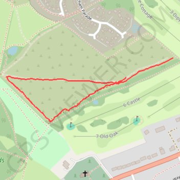
Stafford Castle
- Distance: 0.7 mi
- Elevation gain: 15 m
- Maximum elevation: 112 m
- Elevation loss: 12 m
- Minimum elevation: 97 m
- Moving time: 13 m 21 s
- Moving speed: 3.0 mph
- Maximum speed: 4.5 mph
- Total time: 13 m 58 s
- Global speed: 2.9 mph
Interactive trail map
Thank you for supporting this site ❤️
Make a donation
Make a donation
Gear up for your next adventure:
As an Amazon Associate, this site earns from qualifying purchases at no extra cost to you.
Trail profile
- Distance: 0.7 mi
- Elevation gain: 15 m
- Maximum elevation: 112 m
- Elevation loss: 12 m
- Minimum elevation: 97 m
- Moving time: 13 m 21 s
- Moving speed: 3.0 mph
- Maximum speed: 4.5 mph
- Total time: 13 m 58 s
- Global speed: 2.9 mph
Thank you for supporting this site ❤️
Make a donation
Make a donation
Gear up for your next adventure:
As an Amazon Associate, this site earns from qualifying purchases at no extra cost to you.
About this trail
Name: Stafford Castle trail, distance, elevation, map, profile, GPS track
Coordinates: 52.79841 -2.14476 52.80025 -2.13678
Topography: Staffordshire topographic map, elevation, terrain
Thank you for supporting this site ❤️
Make a donation
Make a donation
Gear up for your next adventure:
As an Amazon Associate, this site earns from qualifying purchases at no extra cost to you.