Gorge Loop Trail in Bogue Chitto State Park
The Gorge Loop Trail offers a serene hiking experience through diverse landscapes of pine-covered hills and lush lowlands. Hikers can enjoy scenic views of the Bogue Chitto River, interspersed with charming bridges and tranquil ponds, while being enveloped by the sounds of rustling leaves and chirping birds. With well-maintained paths and wooden benches for resting, this trail is perfect for both leisurely strolls and nature exploration. #Hiking #Loop #River #Forest #Lake #Nature
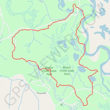
- Distance: 5.0 mi
- Elevation gain: 80 m
- Maximum elevation: 68 m
- Elevation loss: 79 m
- Minimum elevation: 32 m
- Moving time: 1 h 50 m
- Moving speed: 2.7 mph
- Maximum speed: 5.4 mph
- Total time: 2 h 3 m
- Global speed: 2.5 mph
Interactive trail map
Trail profile
- Distance: 5.0 mi
- Elevation gain: 80 m
- Maximum elevation: 68 m
- Elevation loss: 79 m
- Minimum elevation: 32 m
- Moving time: 1 h 50 m
- Moving speed: 2.7 mph
- Maximum speed: 5.4 mph
- Total time: 2 h 3 m
- Global speed: 2.5 mph
About this trail
Name: Gorge Loop Trail in Bogue Chitto State Park trail, distance, elevation, map, profile, GPS track
Start: Gorge Trail, Washington Parish, Louisiana, United States (30.76944 -90.15789)
End: Gorge Trail, Washington Parish, Louisiana, United States (30.76938 -90.15791)
Coordinates: 30.76028 -90.16057 30.78034 -90.14094