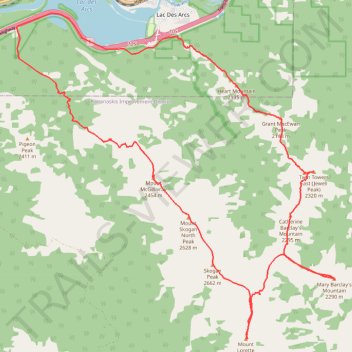
Heart Mountain, Grant McEwan Peak, Twin Towers, Catherine Barclay's Mountain, Mary Barclay's Mountain, Mount Lorette, Skogan Peak, Mount Skogan North Peak and Mount McGillivray Traverse
Loop hike in Bow Valley Wildland Provincial Park
- Distance: 20.0 mi
- Elevation gain: 2,777 m
- Maximum elevation: 2,638 m
- Elevation loss: 2,775 m
- Minimum elevation: 1,292 m
- Moving time: 15 h 3 m
- Moving speed: 1.3 mph
- Maximum speed: 6.3 mph
- Total time: 1 d 3 h
- Global speed: 0.7 mph
Interactive trail map
Trail profile
- Distance: 20.0 mi
- Elevation gain: 2,777 m
- Maximum elevation: 2,638 m
- Elevation loss: 2,775 m
- Minimum elevation: 1,292 m
- Moving time: 15 h 3 m
- Moving speed: 1.3 mph
- Maximum speed: 6.3 mph
- Total time: 1 d 3 h
- Global speed: 0.7 mph
About this trail
Name: Heart Mountain, Grant McEwan Peak, Twin Towers, Catherine Barclay's Mountain, Mary Barclay's Mountain, Mount Lorette, Skogan Peak, Mount Skogan North Peak and Mount McGillivray Traverse trail, distance, elevation, map, profile, GPS track
Coordinates: 50.98635 -115.21010 51.05482 -115.10370