Thank you for supporting this site ❤️
Make a donation
Make a donation
Gear up for your next adventure:
As an Amazon Associate, this site earns from qualifying purchases at no extra cost to you.
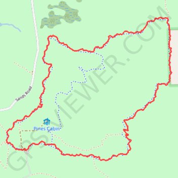
Bloomer Loop Trail - Ortonville State Recreation Area
- Distance: 3.0 mi
- Elevation gain: 60 m
- Maximum elevation: 352 m
- Elevation loss: 60 m
- Minimum elevation: 310 m
- Moving time: 53 m 35 s
- Moving speed: 3.4 mph
- Maximum speed: 14.1 mph
- Total time: 53 m 35 s
- Global speed: 3.4 mph
Interactive trail map
Thank you for supporting this site ❤️
Make a donation
Make a donation
Gear up for your next adventure:
As an Amazon Associate, this site earns from qualifying purchases at no extra cost to you.
Trail profile
- Distance: 3.0 mi
- Elevation gain: 60 m
- Maximum elevation: 352 m
- Elevation loss: 60 m
- Minimum elevation: 310 m
- Moving time: 53 m 35 s
- Moving speed: 3.4 mph
- Maximum speed: 14.1 mph
- Total time: 53 m 35 s
- Global speed: 3.4 mph
Thank you for supporting this site ❤️
Make a donation
Make a donation
Gear up for your next adventure:
As an Amazon Associate, this site earns from qualifying purchases at no extra cost to you.
About this trail
Name: Bloomer Loop Trail - Ortonville State Recreation Area trail, distance, elevation, map, profile, GPS track
Start: Mountain Bike Trail, Oakland County, Michigan, 48462, United States (42.86888 -83.43830)
End: Mountain Bike Trail, Oakland County, Michigan, 48462, United States (42.86886 -83.43838)
Coordinates: 42.86821 -83.44005 42.87763 -83.42523
Thank you for supporting this site ❤️
Make a donation
Make a donation
Gear up for your next adventure:
As an Amazon Associate, this site earns from qualifying purchases at no extra cost to you.