Thank you for supporting this site ❤️
Make a donation
Make a donation
Gear up for your next adventure:
As an Amazon Associate, this site earns from qualifying purchases at no extra cost to you.
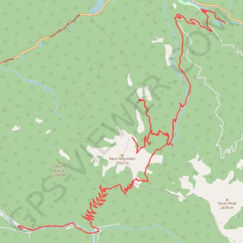
Reco Mountain
- Distance: 22.3 mi
- Elevation gain: 2,231 m
- Maximum elevation: 2,315 m
- Elevation loss: 2,161 m
- Minimum elevation: 985 m
- Moving time: 2 h 2 m
- Moving speed: 10.9 mph
- Maximum speed: 35.4 mph
- Total time: 4 h 13 m
- Global speed: 5.3 mph
Interactive trail map
Thank you for supporting this site ❤️
Make a donation
Make a donation
Gear up for your next adventure:
As an Amazon Associate, this site earns from qualifying purchases at no extra cost to you.
Trail profile
- Distance: 22.3 mi
- Elevation gain: 2,231 m
- Maximum elevation: 2,315 m
- Elevation loss: 2,161 m
- Minimum elevation: 985 m
- Moving time: 2 h 2 m
- Moving speed: 10.9 mph
- Maximum speed: 35.4 mph
- Total time: 4 h 13 m
- Global speed: 5.3 mph
Thank you for supporting this site ❤️
Make a donation
Make a donation
Gear up for your next adventure:
As an Amazon Associate, this site earns from qualifying purchases at no extra cost to you.
About this trail
Name: Reco Mountain trail, distance, elevation, map, profile, GPS track
Coordinates: 49.97452 -117.23198 50.04066 -117.13713
Thank you for supporting this site ❤️
Make a donation
Make a donation
Gear up for your next adventure:
As an Amazon Associate, this site earns from qualifying purchases at no extra cost to you.
Other hiking, mountain biking, running and outdoor activity trails
Click on a trail to view its statistics, map and profile.