Thank you for supporting this site ❤️
Make a donation
Make a donation
Gear up for your next adventure:
As an Amazon Associate, this site earns from qualifying purchases at no extra cost to you.
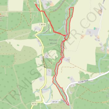
Massey Wood Loop Hike
- Distance: 3.2 mi
- Elevation gain: 194 m
- Maximum elevation: 376 m
- Elevation loss: 191 m
- Minimum elevation: 208 m
- Moving time: 1 h 9 m
- Moving speed: 2.8 mph
- Maximum speed: 5.8 mph
- Total time: 1 h 10 m
- Global speed: 2.8 mph
Interactive trail map
Thank you for supporting this site ❤️
Make a donation
Make a donation
Gear up for your next adventure:
As an Amazon Associate, this site earns from qualifying purchases at no extra cost to you.
Trail profile
- Distance: 3.2 mi
- Elevation gain: 194 m
- Maximum elevation: 376 m
- Elevation loss: 191 m
- Minimum elevation: 208 m
- Moving time: 1 h 9 m
- Moving speed: 2.8 mph
- Maximum speed: 5.8 mph
- Total time: 1 h 10 m
- Global speed: 2.8 mph
Thank you for supporting this site ❤️
Make a donation
Make a donation
Gear up for your next adventure:
As an Amazon Associate, this site earns from qualifying purchases at no extra cost to you.
About this trail
Name: Massey Wood Loop Hike trail, distance, elevation, map, profile, GPS track
Coordinates: 53.23897 -6.32206 53.25309 -6.31315
Thank you for supporting this site ❤️
Make a donation
Make a donation
Gear up for your next adventure:
As an Amazon Associate, this site earns from qualifying purchases at no extra cost to you.
Other hiking, mountain biking, running and outdoor activity trails
Click on a trail to view its statistics, map and profile.
Route1495
Ireland > County Dublin > Shankill
Distance: 24.1 mi • Elevation gain: 949 m • Maximum elevation: 531 m