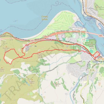
Mynydd y Dref Loop
- Distance: 6.1 mi
- Elevation gain: 325 m
- Maximum elevation: 240 m
- Elevation loss: 330 m
- Minimum elevation: 4 m
- Moving time: 2 h 56 m
- Moving speed: 2.1 mph
- Maximum speed: 4.7 mph
- Total time: 3 h 53 m
- Global speed: 1.6 mph
Interactive trail map
Trail profile
- Distance: 6.1 mi
- Elevation gain: 325 m
- Maximum elevation: 240 m
- Elevation loss: 330 m
- Minimum elevation: 4 m
- Moving time: 2 h 56 m
- Moving speed: 2.1 mph
- Maximum speed: 4.7 mph
- Total time: 3 h 53 m
- Global speed: 1.6 mph
About this trail
Name: Mynydd y Dref Loop trail, distance, elevation, map, profile, GPS track
Start: Railway Terrace, Conwy Marina Village, Conwy, Wales, LL32 8LB, United Kingdom (53.28024 -3.83110)
Coordinates: 53.27865 -3.88176 53.28677 -3.82795
Topography: Conwy topographic map, elevation, terrain
Other hiking, mountain biking, running and outdoor activity trails
Click on a trail to view its statistics, map and profile.
Back from Conwy Mountain Camp
United Kingdom > Wales > Conwy > Conwy > Conwy Marina Village
Conwy Footpaths
Distance: 5.9 mi • Elevation gain: 277 m • Maximum elevation: 190 m
Foel Lus
United Kingdom > Wales > Conwy > Penmaenmawr
Distance: 9.6 mi • Elevation gain: 669 m • Maximum elevation: 354 m