Make a donation
Gear up for your next adventure:
As an Amazon Associate, this site earns from qualifying purchases at no extra cost to you.
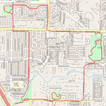
Bicycle ride though Deaver Park, Stoval Park, Allan Saxe Park, and Sublet Linear Park in Arlington TX
- Distance: 7.2 mi
- Elevation gain: 51 m
- Maximum elevation: 207 m
- Elevation loss: 51 m
- Minimum elevation: 190 m
- Moving time: 51 m 45 s
- Moving speed: 8.3 mph
- Maximum speed: 14.3 mph
- Total time: 56 m 30 s
- Global speed: 7.6 mph
Interactive trail map
Make a donation
Gear up for your next adventure:
As an Amazon Associate, this site earns from qualifying purchases at no extra cost to you.
Trail profile
- Distance: 7.2 mi
- Elevation gain: 51 m
- Maximum elevation: 207 m
- Elevation loss: 51 m
- Minimum elevation: 190 m
- Moving time: 51 m 45 s
- Moving speed: 8.3 mph
- Maximum speed: 14.3 mph
- Total time: 56 m 30 s
- Global speed: 7.6 mph
Make a donation
Gear up for your next adventure:
As an Amazon Associate, this site earns from qualifying purchases at no extra cost to you.
About this trail
Name: Bicycle ride though Deaver Park, Stoval Park, Allan Saxe Park, and Sublet Linear Park in Arlington TX trail, distance, elevation, map, profile, GPS track
Start: 6714, Big Springs Drive, Arlington, Tarrant County, Texas, 76001, United States (32.63506 -97.17329)
End: 6717, Big Springs Drive, Arlington, Tarrant County, Texas, 76001, United States (32.63499 -97.17336)
Coordinates: 32.63437 -97.17762 32.65411 -97.15365
Make a donation
Gear up for your next adventure:
As an Amazon Associate, this site earns from qualifying purchases at no extra cost to you.