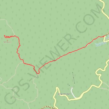
Mount Dunn
Hike to Mount Dunn via The Long Plain Walking Track in the Mount Buffalo National Park. #Hiking #Mountain #Nature #Forest #Park
- Distance: 4.6 mi
- Elevation gain: 256 m
- Maximum elevation: 1,487 m
- Elevation loss: 256 m
- Minimum elevation: 1,298 m
- Moving time: 1 h 20 m
- Moving speed: 3.4 mph
- Maximum speed: 8.1 mph
- Total time: 1 h 28 m
- Global speed: 3.1 mph
Interactive trail map
Trail profile
- Distance: 4.6 mi
- Elevation gain: 256 m
- Maximum elevation: 1,487 m
- Elevation loss: 256 m
- Minimum elevation: 1,298 m
- Moving time: 1 h 20 m
- Moving speed: 3.4 mph
- Maximum speed: 8.1 mph
- Total time: 1 h 28 m
- Global speed: 3.1 mph
About this trail
Name: Mount Dunn trail, distance, elevation, map, profile, GPS track
Start: The Long Plain Walking Track, Mount Buffalo, Alpine Shire, Victoria, Australia (-36.73518 146.80482)
End: The Long Plain Walking Track, Mount Buffalo, Alpine Shire, Victoria, Australia (-36.73503 146.80504)
Coordinates: -36.74260 146.78029 -36.73501 146.80504
Other hiking, mountain biking, running and outdoor activity trails
Click on a trail to view its statistics, map and profile.
Macks Point Track, Mollisons Galleries and Eagle Point Loop
Distance: 13.3 mi • Elevation gain: 751 m • Maximum elevation: 1,514 m