打石石澗
Outdoor hiking
- Distance: 0.8 mi
- Elevation gain: 149 m
- Maximum elevation: 204 m
- Elevation loss: 78 m
- Minimum elevation: 54 m
- Moving time: 26 m 15 s
- Moving speed: 1.9 mph
- Maximum speed: 3.4 mph
- Total time: 3 h 21 m
- Global speed: 0.2 mph
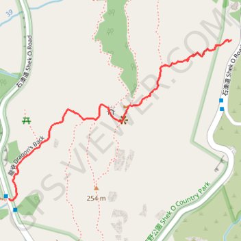
Interactive trail map
Trail profile
- Distance: 0.8 mi
- Elevation gain: 149 m
- Maximum elevation: 204 m
- Elevation loss: 78 m
- Minimum elevation: 54 m
- Moving time: 26 m 15 s
- Moving speed: 1.9 mph
- Maximum speed: 3.4 mph
- Total time: 3 h 21 m
- Global speed: 0.2 mph
About this trail
Name: 打石石澗 trail, distance, elevation, map, profile, GPS track
Start: Shek O Road, Shek O, Southern District, Hong Kong Island, Hong Kong, China (22.23187 114.24694)
Coordinates: 22.22704 114.23970 22.23187 114.24694
Other hiking, mountain biking, running and outdoor activity trails
Click on a trail to view its statistics, map and profile.
Wilson Trail Full Route
China > Hong Kong > Hong Kong Island
Distance: 50.5 mi • Elevation gain: 4,430 m • Maximum elevation: 613 m
Hong Kong island ride
China > Hong Kong > Hong Kong Island
#Bike
Distance: 38.4 mi • Elevation gain: 2,152 m • Maximum elevation: 505 m