Import a GPX file

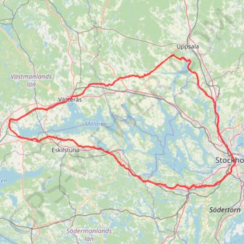
Lake-Mälaren

  • Distance: 209.0 mi
  • Elevation gain: 2,518 m
  • Maximum elevation: 74 m
  • Elevation loss: 2,519 m
  • Minimum elevation: 0 m

Interactive trail map

Trail profile

  • Distance: 209.0 mi
  • Elevation gain: 2,518 m
  • Maximum elevation: 74 m
  • Elevation loss: 2,519 m
  • Minimum elevation: 0 m

About this trail
Gear up for your next adventure:

🧢Thermal Beanie Hats - Prevent heat loss from the head in windy summit conditions
🥾Hiking Boots - Waterproof and durable boots for long-distance hiking in the UK
🧵Survival Paracord - Multi-purpose cordage for emergency repairs and shelters
🛰️Outdoor GPS Navigation - Navigation devices for remote and off-grid areas
🖼️Topographic Map Art - Decorative 3D-effect posters of famous UK peaks and regions

As an Amazon Associate, this site earns from qualifying purchases at no extra cost to you.