Import a GPX file

PR racedayyyy πŸ†πŸ₯ˆ 10k 32:13

  • Distance: 6.4 mi
  • Elevation gain: 18 m
  • Maximum elevation: 8 m
  • Elevation loss: 18 m
  • Minimum elevation: 1 m

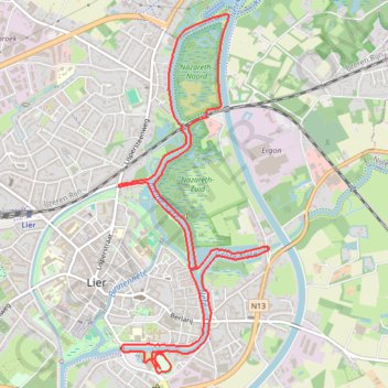
Interactive trail map

Trail profile

  • Distance: 6.4 mi
  • Elevation gain: 18 m
  • Maximum elevation: 8 m
  • Elevation loss: 18 m
  • Minimum elevation: 1 m

About this trail

Name: PR racedayyyy πŸ†πŸ₯ˆ 10k 32:13 trail, distance, elevation, map, profile, GPS track

Start: Aarschotsesteenweg, Lier, Mechelen, Antwerp, Flanders, 2500, Belgium (51.12553 4.57771)

End: Het Netestadion, Aarschotsesteenweg, Lier, Mechelen, Antwerp, Flanders, 2500, Belgium (51.12492 4.57699)

Coordinates: 51.12460 4.57221 51.15010 4.58927

Other hiking, mountain biking, running and outdoor activity trails

Click on a trail to view its statistics, map and profile.

1.3 KOTK 2022

Belgium > Antwerp > Antwerp > Boom > Bosstraat

Distance: 37.0 mi β€’ Elevation gain: 135 m β€’ Maximum elevation: 28 m

1.1 KOTK 2022

Belgium > Antwerp > Mechelen > Mechelen

Distance: 36.2 mi β€’ Elevation gain: 93 m β€’ Maximum elevation: 27 m

KOTK 2022

Belgium > Antwerp > Antwerp > Boom > Bosstraat

Distance: 77.3 mi β€’ Elevation gain: 222 m β€’ Maximum elevation: 28 m

Eurovelo 15 - Strasbourg Rotterdam

France > Grand Est > Bas-Rhin > Strasbourg

Distance: 554.1 mi β€’ Elevation gain: 2,104 m β€’ Maximum elevation: 146 m

Gear up for your next adventure:

🧭Professional Hiking Compasses - High-precision liquid-filled compasses for map reading and orientation
🧣Neck Gaiters - Versatile protection against wind and cold
πŸ‘ŸWaterproof Leg Gaiters - Keep mud and water out of your boots in boggy terrain
🚲Bikepacking Frame Bags - Storage for tools and navigation gear on long off-road rides
πŸ₯ΎTrekking Poles - Poles to improve stability on uneven terrain

As an Amazon Associate, this site earns from qualifying purchases at no extra cost to you.