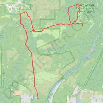
Seminole to Lower Wekiva
Mountain Bike through Seminole State Forest and Lower Wekiva River Preserve State Park. #MTB #Forest #Nature
- Distance: 22.0 mi
- Elevation gain: 67 m
- Maximum elevation: 17 m
- Elevation loss: 68 m
- Minimum elevation: 2 m
- Moving time: 4 h 37 m
- Moving speed: 4.8 mph
- Maximum speed: 19.8 mph
- Total time: 5 h 34 m
- Global speed: 3.9 mph
Interactive trail map
Trail profile
- Distance: 22.0 mi
- Elevation gain: 67 m
- Maximum elevation: 17 m
- Elevation loss: 68 m
- Minimum elevation: 2 m
- Moving time: 4 h 37 m
- Moving speed: 4.8 mph
- Maximum speed: 19.8 mph
- Total time: 5 h 34 m
- Global speed: 3.9 mph
About this trail
Name: Seminole to Lower Wekiva trail, distance, elevation, map, profile, GPS track
Start: Bear Pond Loop, Lake County, Florida, United States (28.81937 -81.42860)
End: Bear Pond Loop, Lake County, Florida, United States (28.81920 -81.42871)
Coordinates: 28.81919 -81.44357 28.89092 -81.38997