Make a donation
Gear up for your next adventure:
As an Amazon Associate, this site earns from qualifying purchases at no extra cost to you.
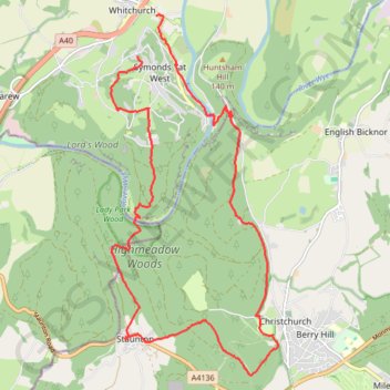
Highmeadow Woods loop from Whitchurch
- Distance: 10.6 mi
- Elevation gain: 451 m
- Maximum elevation: 224 m
- Elevation loss: 560 m
- Minimum elevation: 20 m
- Moving time: 4 h 28 m
- Moving speed: 2.4 mph
- Maximum speed: 18.6 mph
- Total time: 6 h 41 m
- Global speed: 1.6 mph
Interactive trail map
Make a donation
Gear up for your next adventure:
As an Amazon Associate, this site earns from qualifying purchases at no extra cost to you.
Trail profile
- Distance: 10.6 mi
- Elevation gain: 451 m
- Maximum elevation: 224 m
- Elevation loss: 560 m
- Minimum elevation: 20 m
- Moving time: 4 h 28 m
- Moving speed: 2.4 mph
- Maximum speed: 18.6 mph
- Total time: 6 h 41 m
- Global speed: 1.6 mph
Make a donation
Gear up for your next adventure:
As an Amazon Associate, this site earns from qualifying purchases at no extra cost to you.
About this trail
Name: Highmeadow Woods loop from Whitchurch trail, distance, elevation, map, profile, GPS track
Coordinates: 51.80566 -2.66056 51.85381 -2.62437
Topography: Herefordshire topographic map, elevation, terrain
Make a donation
Gear up for your next adventure:
As an Amazon Associate, this site earns from qualifying purchases at no extra cost to you.
Other hiking, mountain biking, running and outdoor activity trails
Click on a trail to view its statistics, map and profile.
Blaze the Biblins
United Kingdom > Wales > Monmouthshire > Ross-on-Wye
Blaze the Biblins, trail race by Monross Trailblazers
Distance: 5.7 mi • Elevation gain: 271 m • Maximum elevation: 154 m
Dean2023-311
United Kingdom > England > Oxfordshire > Oxford
Distance: 192.8 mi • Elevation gain: 3,366 m • Maximum elevation: 290 m