Make a donation
Gear up for your next adventure:
As an Amazon Associate, this site earns from qualifying purchases at no extra cost to you.
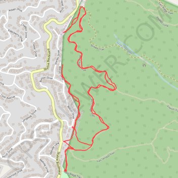
Hike in Reinhardt-Redwood Regional Park
- Distance: 3.6 mi
- Elevation gain: 243 m
- Maximum elevation: 449 m
- Elevation loss: 243 m
- Minimum elevation: 376 m
- Moving time: 1 h 9 m
- Moving speed: 3.1 mph
- Maximum speed: 12.3 mph
- Total time: 1 h 11 m
- Global speed: 3.0 mph
Interactive trail map
Make a donation
Gear up for your next adventure:
As an Amazon Associate, this site earns from qualifying purchases at no extra cost to you.
Trail profile
- Distance: 3.6 mi
- Elevation gain: 243 m
- Maximum elevation: 449 m
- Elevation loss: 243 m
- Minimum elevation: 376 m
- Moving time: 1 h 9 m
- Moving speed: 3.1 mph
- Maximum speed: 12.3 mph
- Total time: 1 h 11 m
- Global speed: 3.0 mph
Make a donation
Gear up for your next adventure:
As an Amazon Associate, this site earns from qualifying purchases at no extra cost to you.
About this trail
Name: Hike in Reinhardt-Redwood Regional Park trail, distance, elevation, map, profile, GPS track
Start: West Ridge Trail, Contra Costa County, California, 94516, United States (37.83140 -122.18526)
Coordinates: 37.82162 -122.18686 37.83144 -122.18275
Make a donation
Gear up for your next adventure:
As an Amazon Associate, this site earns from qualifying purchases at no extra cost to you.
Other hiking, mountain biking, running and outdoor activity trails
Click on a trail to view its statistics, map and profile.
West Ridge, French and Stream Trails Loop in Reinhardt Redwood Regional Park
United States > California > Contra Costa County
The West Ridge, French, and Stream Trails Loop in Reinhardt Redwood Regional Park offers hikers a serene journey through towering coast redwoods, providing ample shade and a tranquil atmosphere. As you navigate the well-marked paths, you'll encounter diverse flora, including ferns and wildflowers, and may spot…
Distance: 4.8 mi • Elevation gain: 402 m • Maximum elevation: 409 m
Loop hike in Reinhardt Redwood Regional Park
United States > California > Contra Costa County
Distance: 3.6 mi • Elevation gain: 210 m • Maximum elevation: 409 m