Thank you for supporting this site ❤️
Make a donation
Make a donation
Gear up for your next adventure:
As an Amazon Associate, this site earns from qualifying purchases at no extra cost to you.
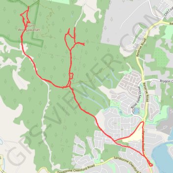
Mount Wongawallan
- Distance: 12.0 mi
- Elevation gain: 870 m
- Maximum elevation: 365 m
- Elevation loss: 870 m
- Minimum elevation: 7 m
- Moving time: 2 h 53 m
- Moving speed: 4.1 mph
- Maximum speed: 10.3 mph
- Total time: 3 h 55 s
- Global speed: 4.0 mph
Interactive trail map
Thank you for supporting this site ❤️
Make a donation
Make a donation
Gear up for your next adventure:
As an Amazon Associate, this site earns from qualifying purchases at no extra cost to you.
Trail profile
- Distance: 12.0 mi
- Elevation gain: 870 m
- Maximum elevation: 365 m
- Elevation loss: 870 m
- Minimum elevation: 7 m
- Moving time: 2 h 53 m
- Moving speed: 4.1 mph
- Maximum speed: 10.3 mph
- Total time: 3 h 55 s
- Global speed: 4.0 mph
Thank you for supporting this site ❤️
Make a donation
Make a donation
Gear up for your next adventure:
As an Amazon Associate, this site earns from qualifying purchases at no extra cost to you.
About this trail
Name: Mount Wongawallan trail, distance, elevation, map, profile, GPS track
Coordinates: -27.89875 153.25293 -27.86389 153.28552
Thank you for supporting this site ❤️
Make a donation
Make a donation
Gear up for your next adventure:
As an Amazon Associate, this site earns from qualifying purchases at no extra cost to you.