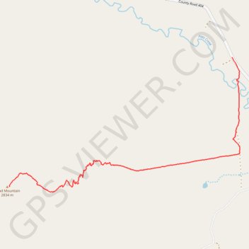
Coming down Coad Mountain
- Distance: 2.7 mi
- Elevation gain: 30 m
- Maximum elevation: 2,866 m
- Elevation loss: 597 m
- Minimum elevation: 2,268 m
- Moving time: 1 h 31 m
- Moving speed: 1.7 mph
- Maximum speed: 3.7 mph
- Total time: 2 h 2 m
- Global speed: 1.3 mph
Interactive trail map
Trail profile
- Distance: 2.7 mi
- Elevation gain: 30 m
- Maximum elevation: 2,866 m
- Elevation loss: 597 m
- Minimum elevation: 2,268 m
- Moving time: 1 h 31 m
- Moving speed: 1.7 mph
- Maximum speed: 3.7 mph
- Total time: 2 h 2 m
- Global speed: 1.3 mph
About this trail
Name: Coming down Coad Mountain trail, distance, elevation, map, profile, GPS track
Start: Carbon County, Wyoming, United States (41.56710 -106.58374)
End: County Road 404, Carbon County, Wyoming, United States (41.57885 -106.55672)
Coordinates: 41.56663 -106.58374 41.57885 -106.55579