Thank you for supporting this site ❤️
Make a donation
Make a donation
Gear up for your next adventure:
As an Amazon Associate, this site earns from qualifying purchases at no extra cost to you.
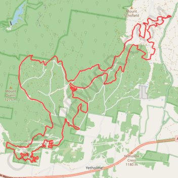
2015-09-13 08:28:08
- Distance: 30.0 mi
- Elevation gain: 1,470 m
- Maximum elevation: 1,276 m
- Elevation loss: 1,469 m
- Minimum elevation: 969 m
Interactive trail map
Thank you for supporting this site ❤️
Make a donation
Make a donation
Gear up for your next adventure:
As an Amazon Associate, this site earns from qualifying purchases at no extra cost to you.
Trail profile
- Distance: 30.0 mi
- Elevation gain: 1,470 m
- Maximum elevation: 1,276 m
- Elevation loss: 1,469 m
- Minimum elevation: 969 m
Thank you for supporting this site ❤️
Make a donation
Make a donation
Gear up for your next adventure:
As an Amazon Associate, this site earns from qualifying purchases at no extra cost to you.
About this trail
Name: 2015-09-13 08:28:08 trail, distance, elevation, map, profile, GPS track
Coordinates: -33.44623 149.77516 -33.38638 149.85550
Thank you for supporting this site ❤️
Make a donation
Make a donation
Gear up for your next adventure:
As an Amazon Associate, this site earns from qualifying purchases at no extra cost to you.