Biking#4
- Distance: 8.1 mi
- Elevation gain: 247 m
- Maximum elevation: 467 m
- Elevation loss: 248 m
- Minimum elevation: 300 m
- Moving time: 42 m 2 s
- Moving speed: 11.5 mph
- Maximum speed: 34.4 mph
- Total time: 42 m 2 s
- Global speed: 11.5 mph
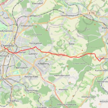
Interactive trail map
Trail profile
- Distance: 8.1 mi
- Elevation gain: 247 m
- Maximum elevation: 467 m
- Elevation loss: 248 m
- Minimum elevation: 300 m
- Moving time: 42 m 2 s
- Moving speed: 11.5 mph
- Maximum speed: 34.4 mph
- Total time: 42 m 2 s
- Global speed: 11.5 mph
About this trail
Name: Biking#4 trail, distance, elevation, map, profile, GPS track
End: 8, Hohe Straße, Kaßberg, Chemnitz, Saxony, 09112, Germany (50.83061 12.91345)
Coordinates: 50.81640 12.91345 50.83099 13.07477