Lena Lake Trail in Olympic National Forest
The Lena Lake Trail in the Olympic National Forest offers hikers a peaceful yet moderately challenging adventure, marked by stunning natural features. Along the route, you'll pass through lush forests filled with moss-covered trees and cross multiple creeks, with a few charming bridges that enhance the experience. The trail culminates at the breathtaking Lena Lake, where the serene, blue-green waters offer a perfect spot for reflection, making the effort worthwhile for both casual walkers and more dedicated hikers. #Hiking #Mountain #Forest #Nature #Lake
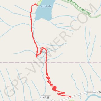
- Distance: 6.0 mi
- Elevation gain: 559 m
- Maximum elevation: 622 m
- Elevation loss: 558 m
- Minimum elevation: 214 m
- Moving time: 2 h 28 m
- Moving speed: 2.4 mph
- Maximum speed: 10.6 mph
- Total time: 3 h 44 m
- Global speed: 1.6 mph
Interactive trail map
Trail profile
- Distance: 6.0 mi
- Elevation gain: 559 m
- Maximum elevation: 622 m
- Elevation loss: 558 m
- Minimum elevation: 214 m
- Moving time: 2 h 28 m
- Moving speed: 2.4 mph
- Maximum speed: 10.6 mph
- Total time: 3 h 44 m
- Global speed: 1.6 mph
About this trail
Name: Lena Lake Trail in Olympic National Forest trail, distance, elevation, map, profile, GPS track
Coordinates: 47.59968 -123.16444 47.62041 -123.15101
Other hiking, mountain biking, running and outdoor activity trails
Click on a trail to view its statistics, map and profile.
Lena Lake Trail in Olympic National Forest
United States > Washington > Mason County
The Lena Lake Trail in the Olympic National Forest offers a serene hiking experience through lush, old-growth forests, with stretches of vibrant rhododendron blooms during late spring. As you climb toward the lake, you'll encounter views of moss-covered trees, trickling streams, and the tranquil waters of Lena…
Distance: 5.1 mi • Elevation gain: 524 m • Maximum elevation: 618 m