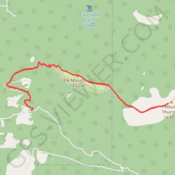
Elk Mountain - Mount Thurston
- Distance: 8.9 mi
- Elevation gain: 1,063 m
- Maximum elevation: 1,579 m
- Elevation loss: 1,063 m
- Minimum elevation: 636 m
Interactive trail map
Trail profile
- Distance: 8.9 mi
- Elevation gain: 1,063 m
- Maximum elevation: 1,579 m
- Elevation loss: 1,063 m
- Minimum elevation: 636 m
About this trail
Name: Elk Mountain - Mount Thurston trail, distance, elevation, map, profile, GPS track
Coordinates: 49.10434 -121.83026 49.11669 -121.76899
Other hiking, mountain biking, running and outdoor activity trails
Click on a trail to view its statistics, map and profile.
Chilliwack - Hope
Canada > British Columbia > Fraser Valley Regional District > Chilliwack
Fraser River. #Bike
Distance: 41.6 mi • Elevation gain: 526 m • Maximum elevation: 88 m
Elk Mountain
Canada > British Columbia > Fraser Valley Regional District > Chilliwack
#Hiking #Snowshoeing #Elk
Distance: 5.3 mi • Elevation gain: 785 m • Maximum elevation: 1,414 m