Import a GPX file

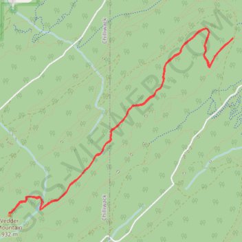
Vedder Mountain Ridge Trail

#Hiking #MTB

  • Distance: 5.5 mi
  • Elevation gain: 312 m
  • Maximum elevation: 888 m
  • Elevation loss: 312 m
  • Minimum elevation: 665 m

Interactive trail map

Trail profile

  • Distance: 5.5 mi
  • Elevation gain: 312 m
  • Maximum elevation: 888 m
  • Elevation loss: 312 m
  • Minimum elevation: 665 m

About this trail
Other hiking, mountain biking, running and outdoor activity trails

Click on a trail to view its statistics, map and profile.
Vancouver - Golden

Canada > British Columbia > Metro Vancouver Regional District > Vancouver

#Bike #Vancouver #Golden

Distance: 514.2 mi • Elevation gain: 9,376 m • Maximum elevation: 1,347 m

Tsawwassen - Chilliwack

Canada > British Columbia > Metro Vancouver Regional District

#Bike #Tsawwassen #Chilliwack

Distance: 61.4 mi • Elevation gain: 500 m • Maximum elevation: 126 m

Gear up for your next adventure:

🧺Microfibre Travel Towels - Fast-drying and compact towels for wild swimming and camping
🧢Hiking Hats - Sun and weather protection for outdoor walks
🥾Men's Waterproof Hiking Boots - Durable footwear with deep lugs for muddy and rocky UK terrains
🥾Hiking Boots - Waterproof and durable boots for long-distance hiking in the UK
🗺️Ordnance Survey Maps - Official UK maps for walking and outdoor activities

As an Amazon Associate, this site earns from qualifying purchases at no extra cost to you.