Make a donation
Gear up for your next adventure:
As an Amazon Associate, this site earns from qualifying purchases at no extra cost to you.
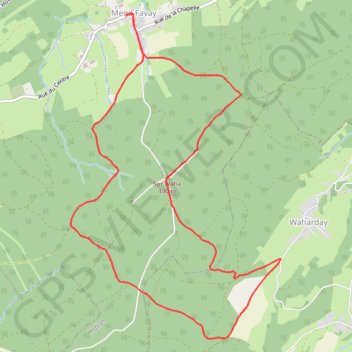
Enil Favay - Hotton - Province du Luxembourg - Belgique
- Distance: 6.4 mi
- Elevation gain: 217 m
- Maximum elevation: 401 m
- Elevation loss: 218 m
- Minimum elevation: 266 m
Interactive trail map
Make a donation
Gear up for your next adventure:
As an Amazon Associate, this site earns from qualifying purchases at no extra cost to you.
Trail profile
- Distance: 6.4 mi
- Elevation gain: 217 m
- Maximum elevation: 401 m
- Elevation loss: 218 m
- Minimum elevation: 266 m
Make a donation
Gear up for your next adventure:
As an Amazon Associate, this site earns from qualifying purchases at no extra cost to you.
About this trail
Name: Enil Favay - Hotton - Province du Luxembourg - Belgique trail, distance, elevation, map, profile, GPS track
Coordinates: 50.22104 5.43218 50.24972 5.46112
Make a donation
Gear up for your next adventure:
As an Amazon Associate, this site earns from qualifying purchases at no extra cost to you.
Other hiking, mountain biking, running and outdoor activity trails
Click on a trail to view its statistics, map and profile.
Riethoven naar Oostenrijk
Netherlands > North Brabant > Riethoven > Eind
Distance: 573.0 mi • Elevation gain: 13,629 m • Maximum elevation: 1,897 m
Eurovelo 15 - Strasbourg Rotterdam
France > Grand Est > Bas-Rhin > Strasbourg
Distance: 554.1 mi • Elevation gain: 2,104 m • Maximum elevation: 146 m
LT25_FINAL
Belgium > Luxembourg > Bastogne > Mont
Distance: 171.5 mi • Elevation gain: 10,191 m • Maximum elevation: 626 m