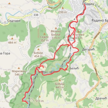
Gradac
- Distance: 11.5 mi
- Elevation gain: 523 m
- Maximum elevation: 397 m
- Elevation loss: 525 m
- Minimum elevation: 188 m
- Moving time: 5 h 32 m
- Moving speed: 2.1 mph
- Maximum speed: 5.5 mph
- Total time: 8 h 37 m
- Global speed: 1.3 mph
Interactive trail map
Trail profile
- Distance: 11.5 mi
- Elevation gain: 523 m
- Maximum elevation: 397 m
- Elevation loss: 525 m
- Minimum elevation: 188 m
- Moving time: 5 h 32 m
- Moving speed: 2.1 mph
- Maximum speed: 5.5 mph
- Total time: 8 h 37 m
- Global speed: 1.3 mph
About this trail
Name: Gradac trail, distance, elevation, map, profile, GPS track
Coordinates: 44.21914 19.85494 44.26226 19.89302
Other hiking, mountain biking, running and outdoor activity trails
Click on a trail to view its statistics, map and profile.
Gradac
Serbia > Central Serbia > Kolubara Administrative District > Valjevo
Distance: 10.9 mi • Elevation gain: 627 m • Maximum elevation: 397 m
Klisura reke Gradac (kružna)
Serbia > Central Serbia > Kolubara Administrative District > Lelic
Distance: 8.2 mi • Elevation gain: 471 m • Maximum elevation: 523 m
2022_Yu
Slovenia > Ajdovščina > Žapuže
Distance: 1,526.9 mi • Elevation gain: 32,048 m • Maximum elevation: 1,950 m
Kanjon reke Gradac: Degurić - izvor reke Gradac
Serbia > Central Serbia > Kolubara Administrative District > Deguric
Distance: 6.0 mi • Elevation gain: 369 m • Maximum elevation: 312 m