Make a donation
Gear up for your next adventure:
As an Amazon Associate, this site earns from qualifying purchases at no extra cost to you.
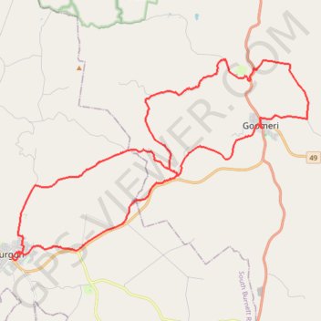
Murgon to Goomeri
Mutgon, Moondooner, Manyung, Goomeri, Queensland
- Distance: 32.0 mi
- Elevation gain: 622 m
- Maximum elevation: 439 m
- Elevation loss: 622 m
- Minimum elevation: 235 m
- Moving time: 3 h 59 s
- Moving speed: 10.6 mph
- Maximum speed: 39.9 mph
- Total time: 4 h 8 m
- Global speed: 7.7 mph
Interactive trail map
Make a donation
Gear up for your next adventure:
As an Amazon Associate, this site earns from qualifying purchases at no extra cost to you.
Trail profile
- Distance: 32.0 mi
- Elevation gain: 622 m
- Maximum elevation: 439 m
- Elevation loss: 622 m
- Minimum elevation: 235 m
- Moving time: 3 h 59 s
- Moving speed: 10.6 mph
- Maximum speed: 39.9 mph
- Total time: 4 h 8 m
- Global speed: 7.7 mph
Make a donation
Gear up for your next adventure:
As an Amazon Associate, this site earns from qualifying purchases at no extra cost to you.
About this trail
Name: Murgon to Goomeri trail, distance, elevation, map, profile, GPS track
Start: Lamb Street, Murgon, South Burnett Regional, Queensland, Australia (-26.24340 151.94343)
End: Lamb Street, Murgon, South Burnett Regional, Queensland, Australia (-26.24337 151.94341)
Coordinates: -26.24408 151.94271 -26.15291 152.09212
Make a donation
Gear up for your next adventure:
As an Amazon Associate, this site earns from qualifying purchases at no extra cost to you.
Other hiking, mountain biking, running and outdoor activity trails
Click on a trail to view its statistics, map and profile.
Murgon to Cloyna via Boat Mountain
Australia > Queensland > Murgon
Murgon, Tablelends, Merlwood, Warnung, Cloyna, Byee, Barlil, Queensland
Distance: 32.9 mi • Elevation gain: 651 m • Maximum elevation: 512 m
Murgon and Wondai streets
Australia > Queensland > Murgon
Distance: 24.1 mi • Elevation gain: 339 m • Maximum elevation: 349 m
Tinny-Murgon
Australia > Queensland > Tingoora
Rail trail and roads Tingoora to Murgon
Distance: 31.5 mi • Elevation gain: 412 m • Maximum elevation: 414 m