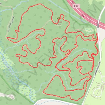
Bacon Ridge Natural Area loop trails
Morning hike
- Distance: 5.0 mi
- Elevation gain: 121 m
- Maximum elevation: 43 m
- Elevation loss: 121 m
- Minimum elevation: 11 m
- Moving time: 2 h 8 m
- Moving speed: 2.3 mph
- Maximum speed: 5.1 mph
- Total time: 2 h 27 m
- Global speed: 2.0 mph
Interactive trail map
Trail profile
- Distance: 5.0 mi
- Elevation gain: 121 m
- Maximum elevation: 43 m
- Elevation loss: 121 m
- Minimum elevation: 11 m
- Moving time: 2 h 8 m
- Moving speed: 2.3 mph
- Maximum speed: 5.1 mph
- Total time: 2 h 27 m
- Global speed: 2.0 mph
About this trail
Name: Bacon Ridge Natural Area loop trails trail, distance, elevation, map, profile, GPS track
Start: Hawkins Road, Anne Arundel County, Maryland, 21140, United States (39.00689 -76.60832)
End: Hawkins Road, Anne Arundel County, Maryland, 21140, United States (39.00685 -76.60832)
Coordinates: 39.00183 -76.61698 39.00906 -76.60822