Thank you for supporting this site ❤️
Make a donation
Make a donation
Gear up for your next adventure:
As an Amazon Associate, this site earns from qualifying purchases at no extra cost to you.
Lane Cove Riverside Walk
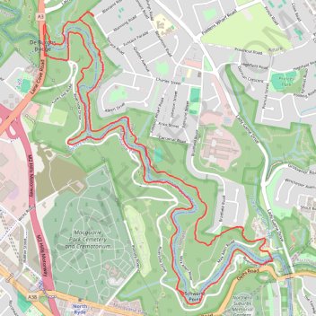
Interactive trail map
Thank you for supporting this site ❤️
Make a donation
Make a donation
Gear up for your next adventure:
As an Amazon Associate, this site earns from qualifying purchases at no extra cost to you.
Trail profile
- Distance: 6.5 mi
- Elevation gain: 200 m
- Maximum elevation: 48 m
- Elevation loss: 201 m
- Minimum elevation: 4 m
- Moving time: 1 h 22 m
- Moving speed: 4.8 mph
- Maximum speed: 11.0 mph
- Total time: 1 h 23 m
- Global speed: 4.7 mph
Thank you for supporting this site ❤️
Make a donation
Make a donation
Gear up for your next adventure:
As an Amazon Associate, this site earns from qualifying purchases at no extra cost to you.
About this trail
Name: Lane Cove Riverside Walk trail, distance, elevation, map, profile, GPS track
Coordinates: -33.79479 151.13554 -33.77333 151.15575
Thank you for supporting this site ❤️
Make a donation
Make a donation
Gear up for your next adventure:
As an Amazon Associate, this site earns from qualifying purchases at no extra cost to you.
Other hiking, mountain biking, running and outdoor activity trails
Click on a trail to view its statistics, map and profile.
Hike through Lane Cove National Park along the Great North Walk
Australia > New South Wales > Sydney
Distance: 8.7 mi • Elevation gain: 336 m • Maximum elevation: 170 m