Monona County - Base
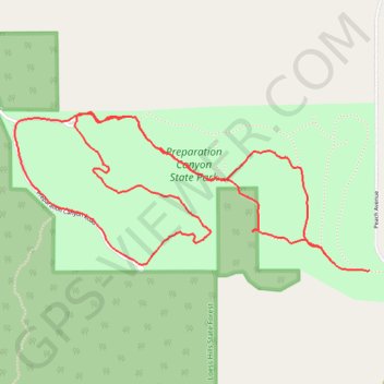
Trail run in Preparation Canyon State Park, Monona County, IA
- Distance: 4.3 mi
- Elevation gain: 170 m
- Maximum elevation: 427 m
- Elevation loss: 168 m
- Minimum elevation: 338 m
- Moving time: 59 m 13 s
- Moving speed: 4.4 mph
- Maximum speed: 8.7 mph
- Total time: 1 h 17 s
- Global speed: 4.3 mph
Interactive trail map
Trail profile
- Distance: 4.3 mi
- Elevation gain: 170 m
- Maximum elevation: 427 m
- Elevation loss: 168 m
- Minimum elevation: 338 m
- Moving time: 59 m 13 s
- Moving speed: 4.4 mph
- Maximum speed: 8.7 mph
- Total time: 1 h 17 s
- Global speed: 4.3 mph
About this trail
Name: Monona County - Base trail, distance, elevation, map, profile, GPS track
Start: Peach Avenue, Monona County, Iowa, 51558, United States (41.88875 -95.89619)
End: Peach Avenue, Monona County, Iowa, 51558, United States (41.88946 -95.89884)
Coordinates: 41.88872 -95.91759 41.89583 -95.89619