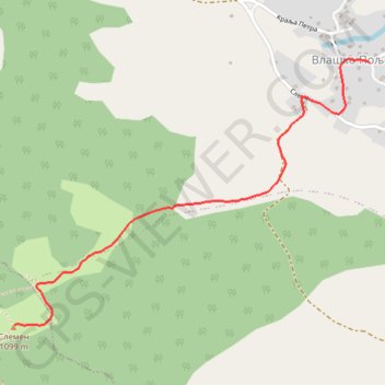
Slemen
2.425 km
- Distance: 1.5 mi
- Elevation gain: 336 m
- Maximum elevation: 1,096 m
- Elevation loss: 0 m
- Minimum elevation: 760 m
- Moving time: 40 m 20 s
- Moving speed: 2.3 mph
- Maximum speed: 2.4 mph
- Total time: 40 m 20 s
- Global speed: 2.3 mph
Interactive trail map
Trail profile
- Distance: 1.5 mi
- Elevation gain: 336 m
- Maximum elevation: 1,096 m
- Elevation loss: 0 m
- Minimum elevation: 760 m
- Moving time: 40 m 20 s
- Moving speed: 2.3 mph
- Maximum speed: 2.4 mph
- Total time: 40 m 20 s
- Global speed: 2.3 mph
About this trail
Name: Slemen trail, distance, elevation, map, profile, GPS track
Coordinates: 43.68964 22.05534 43.69960 22.07370
Other hiking, mountain biking, running and outdoor activity trails
Click on a trail to view its statistics, map and profile.
2022_Yu
Slovenia > Ajdovščina > Žapuže
Distance: 1,526.9 mi • Elevation gain: 32,048 m • Maximum elevation: 1,950 m