Thank you for supporting this site ❤️
Make a donation
Make a donation
Gear up for your next adventure:
As an Amazon Associate, this site earns from qualifying purchases at no extra cost to you.
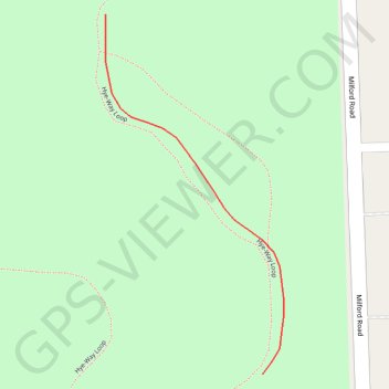
Trails in Highland Oaks County Park in Highland Township, MI
- Distance: 0.1 mi
- Elevation gain: 2 m
- Maximum elevation: 313 m
- Elevation loss: 2 m
- Minimum elevation: 311 m
- Moving time: 2 m
- Moving speed: 3.1 mph
- Maximum speed: 3.7 mph
- Total time: 2 m
- Global speed: 3.1 mph
Interactive trail map
Thank you for supporting this site ❤️
Make a donation
Make a donation
Gear up for your next adventure:
As an Amazon Associate, this site earns from qualifying purchases at no extra cost to you.
Trail profile
- Distance: 0.1 mi
- Elevation gain: 2 m
- Maximum elevation: 313 m
- Elevation loss: 2 m
- Minimum elevation: 311 m
- Moving time: 2 m
- Moving speed: 3.1 mph
- Maximum speed: 3.7 mph
- Total time: 2 m
- Global speed: 3.1 mph
Thank you for supporting this site ❤️
Make a donation
Make a donation
Gear up for your next adventure:
As an Amazon Associate, this site earns from qualifying purchases at no extra cost to you.
About this trail
Name: Trails in Highland Oaks County Park in Highland Township, MI trail, distance, elevation, map, profile, GPS track
Coordinates: 42.69414 -83.60693 42.69537 -83.60610
Thank you for supporting this site ❤️
Make a donation
Make a donation
Gear up for your next adventure:
As an Amazon Associate, this site earns from qualifying purchases at no extra cost to you.