Thank you for supporting this site ❤️
Make a donation
Make a donation
Gear up for your next adventure:
As an Amazon Associate, this site earns from qualifying purchases at no extra cost to you.
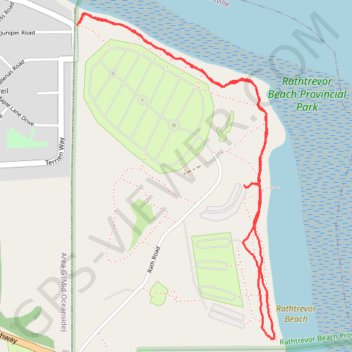
Rathtrevor Beach Park
Vancouver Island. #Hiking #Running #RathtrevorBeach #Vancouver
- Distance: 2.7 mi
- Elevation gain: 75 m
- Maximum elevation: 20 m
- Elevation loss: 75 m
- Minimum elevation: 3 m
Interactive trail map
Thank you for supporting this site ❤️
Make a donation
Make a donation
Gear up for your next adventure:
As an Amazon Associate, this site earns from qualifying purchases at no extra cost to you.
Trail profile
- Distance: 2.7 mi
- Elevation gain: 75 m
- Maximum elevation: 20 m
- Elevation loss: 75 m
- Minimum elevation: 3 m
Thank you for supporting this site ❤️
Make a donation
Make a donation
Gear up for your next adventure:
As an Amazon Associate, this site earns from qualifying purchases at no extra cost to you.
About this trail
Name: Rathtrevor Beach Park trail, distance, elevation, map, profile, GPS track
Coordinates: 49.31522 -124.27543 49.32791 -124.26367
Thank you for supporting this site ❤️
Make a donation
Make a donation
Gear up for your next adventure:
As an Amazon Associate, this site earns from qualifying purchases at no extra cost to you.
Other hiking, mountain biking, running and outdoor activity trails
Click on a trail to view its statistics, map and profile.