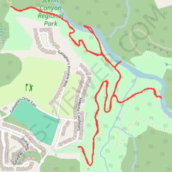
Mission Creek Greenway
Scenic Canyon Regional Park. #Hiking #ScenicCanyon
- Distance: 4.0 mi
- Elevation gain: 208 m
- Maximum elevation: 542 m
- Elevation loss: 208 m
- Minimum elevation: 464 m
Interactive trail map
Trail profile
- Distance: 4.0 mi
- Elevation gain: 208 m
- Maximum elevation: 542 m
- Elevation loss: 208 m
- Minimum elevation: 464 m
About this trail
Name: Mission Creek Greenway trail, distance, elevation, map, profile, GPS track
Coordinates: 49.83830 -119.37511 49.84828 -119.36048
Other hiking, mountain biking, running and outdoor activity trails
Click on a trail to view its statistics, map and profile.