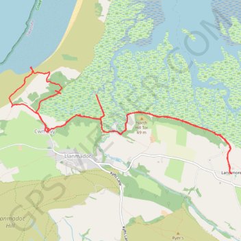
Llandimore Marsh
- Distance: 7.9 mi
- Elevation gain: 221 m
- Maximum elevation: 32 m
- Elevation loss: 221 m
- Minimum elevation: 0 m
- Moving time: 3 h 50 m
- Moving speed: 2.0 mph
- Maximum speed: 3.2 mph
- Total time: 6 h 40 m
- Global speed: 1.2 mph
Interactive trail map
Trail profile
- Distance: 7.9 mi
- Elevation gain: 221 m
- Maximum elevation: 32 m
- Elevation loss: 221 m
- Minimum elevation: 0 m
- Moving time: 3 h 50 m
- Moving speed: 2.0 mph
- Maximum speed: 3.2 mph
- Total time: 6 h 40 m
- Global speed: 1.2 mph
About this trail
Name: Llandimore Marsh trail, distance, elevation, map, profile, GPS track
Coordinates: 51.61466 -4.26477 51.62871 -4.21737
Topography: Swansea topographic map, elevation, terrain
Other hiking, mountain biking, running and outdoor activity trails
Click on a trail to view its statistics, map and profile.
Gower National Landscape Day 5
United Kingdom > Wales > Swansea > Landimore
Distance: 12.9 mi • Elevation gain: 174 m • Maximum elevation: 59 m
Gower National Landscape Day 4
United Kingdom > Wales > Swansea > Llangennith
Distance: 11.6 mi • Elevation gain: 254 m • Maximum elevation: 59 m